
Problem with JPEG Export
Answered
Hello,
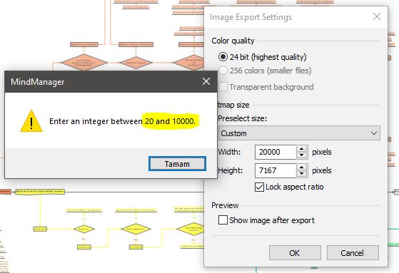
When I want to export the map as JPG, it allows a maximum resolution of 10,000 pixels. Screenshot attached. In a detailed map study, this resolution is not sufficient. When comprehensive works are transferred as JPG, the texts cannot be read. For this reason, if the export resolution can be increased up to 20,000 pixels, a healthier JPG file will be created. I would be grateful if an update could be made on this subject in the future. Thanks.
With all respect.
Support case ID #3256332
Files:
Resolution Prob...
The attached draft macro will export a PNG image of a map up to about 27,000 pixels, above which other problems seem to occur.
To use it:
Large graphics files can exceed 30 MB so deploying them might be challenging.
The attached draft macro will export a PNG image of a map up to about 27,000 pixels, above which other problems seem to occur.
To use it:
Large graphics files can exceed 30 MB so deploying them might be challenging.
You could try experimenting with "printing" the image as a high-resolution JPEG file via a virtual image printer, like Image Printer Pro. This gives me slightly better text than the maximum resolution you get by exporting to a JPEG, but it didn't do as good a job at rendering topic fill colours. However, I get the impression from your example that the map you are trying to print is fairly large and the topics have small print, which is going to be a difficult combination to turn into a readable image. Edit: one alternative would be to publish the map and share the URL.
Also, if you want to propose a change like this to be incorporated in a future version it might be better to post it as an idea rather than a question so that people can vote on it.
YTB, that must be an impressive map! I just credited you 30 points to upgrade you to Contributor on this forum, congrats!
YTB, that must be an impressive map! I just credited you 30 points to upgrade you to Contributor on this forum, congrats!
---